Updated 9/19
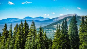
Soar high among 14,000 foot peaks and breathe in the crisp air on the Collegiate Peaks Scenic Drive in Colorado!
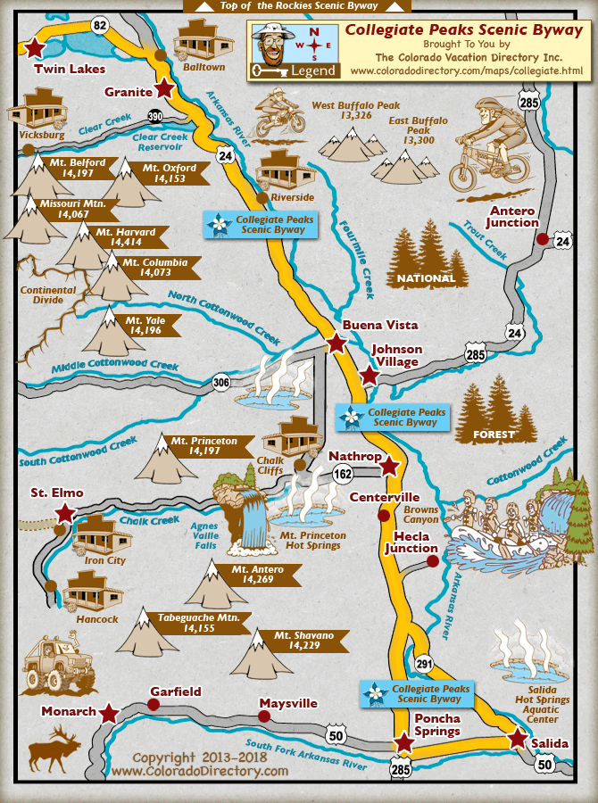
THE ROUTE OF THE COLLEGIATE PEAKS SCENIC BYWAY
The Collegiate Peaks Scenic Drive is an old stagecoach route through canyons carved by the Arkansas River in Colorado. The American Gold Rush, dancing waters, white cliffs and ghost towns are awaiting you!
The paved scenic route is 57 miles long and took us hours to drive since we stopped to admire vistas and take photographs. If you drive straight through, you can travel the portion in Chalk Creek Canyon in only 2-3 hours. The scenic byway takes you to scenic vistas, through ranch lands, and connects Salida to Granite, Colorado.
WHAT YOU WILL SEE
The Collegiate Peaks Scenic Byway has historic buildings, such as the Old Nathrop Schoolhouse built in 1881 and the Gas Creek School built in 1890, used until 1942. Be sure to visit the Hutchinson Ranch, an 1870’s homestead registered with the National Historic Registry. The Buena Vista Heritage Museum, completed in 1883, gives visitors an opportunity to learn more about Buena Vista, Colorado.
You will see Midland Tunnels. These tunnels are the remains of the Midland Railroad, the area’s first standard gauge railroad. The Midland Railroad Company had to dig into the hillside, creating a series of short tunnels for the train to pass through. You can also hike the tunnels.
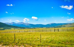
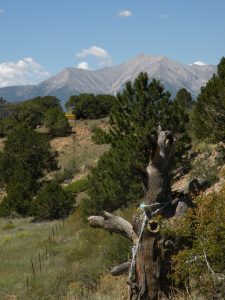
This scenic drive parallels the Continental Divide at the foot of the Sawatch Range, which is the highest concentration of 14,000+ foot peaks in America. The route follows the Arkansas River, the most commercially rafted river in the U.S. The entire route rises above 14,000 feet elevation and includes the summits of Mount Princeton, Mount Yale and Mount Harvard.
Look into driving the Highway of the Fourteeners, a 19-mile stretch of highway with views of 10 of Colorado’s fourteeners. From this highway you can view Mounts Princeton, Yale, Columbia, Harvard, Belford, Oxford, Huron, La Plata, Elbert, and Missouri Mountain. The area is filled with sparkling lakes, scenic overlooks and the 13,000 foot Buffalo Peaks. Get off-road to explore the roads off the Collegiate Peaks byway and discover the wilderness!
HOW TO GET TO THE COLLEGIATE PEAKS SCENIC BYWAY
Start in either Salida or Poncha Springs and make your way north to Highway 25. From there, you’ll pass through Centerville, Nathrop, Buena Vista, and Riverside. Find the end of your trip at Granite. The byway also connects to the nearby Top of the Rockies Scenic Byway and West Elk Loop Scenic Byway.
CHALK CREEK CANYON IS JUST OFF THE BYWAY
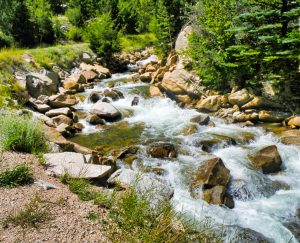
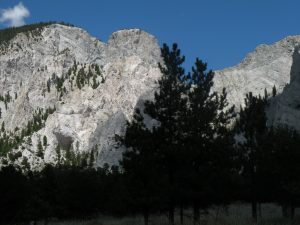
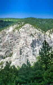
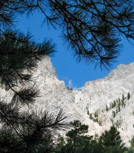
Chalk Creek is about 27 miles long and is named for the white kaolinite cliffs that you see at the entrance to the Chalk Creek Valley. They are a result of hot springs deposits.
The Arkansas River is closely tied to the silver and gold rushes in Colorado during the 1800s. Several towns and structures grew as gold prospectors invaded the mountains, including St. Elmo, Hancock and the groundbreaking Alpine Tunnel. The Mary Murphy Mine, one of the most productive mines in Colorado, is located in Chalk Creek Canyon.
The Denver, South Park and Pacific Railroads all followed Chalk Creek Canyon into the Alpine Tunnel. The tunnel was built to allow trains to transport ore and supplies to and from Gunnison, Colorado. The rail route was closed for safety reasons once the gold rush was over.
The end of the gold rush in the late 19th and 20th centuries turned St. Elmo (listed on the National Register of Historic Places) and the other towns into ghost towns.
HOW TO GET TO CHALK CREEK CANYON
From Buena Vista, Colorado, drive south for about 7 miles on Highway 285. Turn right onto County Road 162, and drive west passing the Mr. Princeton Hot Springs Resort (a private property), for 6 miles. An information kiosk is located on the right side of the road, just across from the Colorado Trail (#1776) Trailhead.
GHOST TOWNS IN CHALK CREEK CANYON
St. Elmo
St. Elmo is on County Road 162, 15 miles west of Nathrop, Colorado and Highway 285. The last 5 miles of the road is graded dirt.
The town was settled in 1871 by the man who discovered the Mary Murphy Mine. Dr. Abner Ellis Wright is known to have had only one ear because of a grizzly attack while he was mining.
In 1880, the Upper Chalk Creek/Grizzly Gulch area had a population of nearly 2,000 with dozens of mines on the mountains. St. Elmo prospered for 30 years, but there was a silver crash in 1893. By WWI, the town was in decline and the last resident died 1960.
It is an interesting ghost town today but all the buildings are in private ownership. Visitors are only allowed to walk the boardwalks and buy snacks and trinkets from a souvenir store.
Hancock
To reach Hancock, take a left onto County Road 295 just before you enter St. Elmo. Follow the road for 5 miles until you reach Hancock and the trailhead to the Alpine Tunnel.
On the final 5 miles to Hancock, look for ruins of the Mary Murphy mine and the mining camp of Romley. Note that you will need a 4WD vehicle to take the drive up to the Mary Murphy Mine. You can drive nearly up to the Alpine Tunnel from Hancock, if you have a 4WD vehicle. Otherwise, it is a 2-mile hike to the closed Tunnel entrance.
Hancock served the workers who built the Alpine Tunnel. Mining was secondary in Hancock. The tunnel was completed in 1881, but the train ran through Hancock carrying miners, passengers and supplies. It is said Mark Twain once took the train ride just for the experience.
At its most prosperous, Hancock had a population of about 200 people, mostly miners and railway workers. The town is at 11,027 feet in elevation and living was very harsh. The town was abandoned in 1910 when the Alpine Tunnel closed. The last mine in Hancock closed in 1926. The only thing remaining in Hancock is the foundation of an old saloon. But there are fascinating ruins on the 5-mile drive from St. Elmo to Hancock on County Road 295. The wooden remnants of mines turn an indescribable russet-red at this elevation and make interesting photographs.
THE ALPINE TUNNEL
Hancock Pass has an elevation of 12,140 feet, is in the San Isabel National Forest and crosses the Continental Divide. You can only reach The Alpine Tunnel via a jeep trail in a sturdy 4X4 or by hiking. The drive is 11.6 miles long and takes about 4 hours on rocky surfaces.There is a restored train depot at the Tunnel Entrance.
The Collegiate Peaks Scenic Drive is one of the most beautiful you will ever take in America and becomes more inspiring the higher the elevation. In early fall, the Aspen trees are breathtaking, showing off golden and russet leaves. You can see the white Chalk Cliffs for miles in all directions.
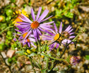
Stop and fish for trout, hunt for aquamarines on Mt. Antero and garnets on Mt. Princeton, follow jeep trails, hike the hundreds of trails along the route, visit classic mining towns, see flower-filled meadows and cool off in rushing waters. The Collegiate Peaks Scenic Drive is a must!