August 13, 2018

WATERFALL ROAD TRIP IN NORTH CAROLINA

Take a backroads trip to see waterfalls in North Carolina! 


As we had lunch at one of the many outdoor restaurants in Asheville, North Carolina, we were surrounded by lush green mountains and cool summer breezes. Asheville is so hard to leave! But we had agreed to head further west and south to see some of North Carolina’s many waterfalls.


We set off to drive Highway 64 in western North Carolina to find out why it is sometimes called the Waterfalls Byway. Highway 64 covers 604 miles from the Tennessee state line to the Outer Banks. This route has been used since the Model T era and snakes through the North Carolina mountains. Travelers pass waterfalls, drive through gorges and mountain towns you will not forget.


We traveled the 150-mile stretch of Highway 64 near Asheville, North Carolina. This winding 2-lane backroad is now one of our favorites in America!


This route took us a couple of days to drive since we stopped in several charming towns and took hundreds of photos. If you don’t make any stops, the route could be traveled in a few hours. 


Looking Glass Falls photo by Stu Schaefer


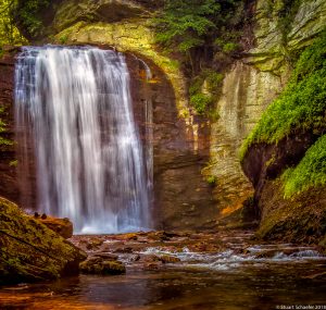
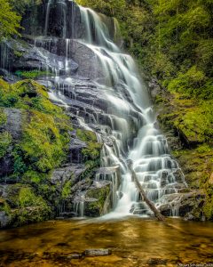
WATERFALLS: (a short list)

We recommend the following waterfalls on or near Highway 64:


Bridal Veil Falls 
2.5 miles east of Highlands on US 64. Visible from the highway. Height 120 feet. There is a hike of 4.6 miles too. Hike across a covered bridge over the High Falls and visit Lake Julia. 


Catawba Falls
I-40 E. to exit 73.  Catawba Falls Rd.  2.5 mile roundtrip.  Moderately difficult trail.


Connestee Falls
Take 276 south to falls that are just off the road.


Courthouse Falls
On Courthouse Creek, in the Beech Gap area of Pisgah National Forest. Take US 64, 16 miles east from Cashiers, turn north on SR 215 to Balsam Grove and Courthouse Creek.


Crabtree Falls
Drive to Milepost 339 on the Blue Ridge Parkway.  Turn right into the Crabtree Falls Campground.  2.5 mile loop.  The trail to Crabtree Falls is in the forest. The trail loops to the Upper Crabtree Falls. Moderate to strenuous difficulty.


Cullasaja Falls
Visible from US 64, in Cullasaja Gorge.  Cullasaja Falls is 11 miles east from Franklin, 9 miles west from Highlands. Height 250 feet. Accessible by foot trail, 1/2 mile, steep rough terrain.


Dry Falls
Located near US 64,  3.5 miles west of Highlands, 16.5 miles east of Franklin. Paved walkway underneath 75 foot falls. Hike is only .25 miles round trip.


DuPont State Forest Three Waterfalls Hike

This moderate hike is 4.5 miles roundtrip but you will see beautiful cascades in less than 5 minutes on this trail. You will see Triple Falls, High Falls, and Hooker Falls. Triple Falls was the location for the movies, The Hunger Games and The Last of the Mohicans.


Glen Falls
From Highlands, travel 3 miles south on NC 106, turn left on US Forest Service Rd with “Glen Falls” marker. 1 mile trail to falls is steep and rough. 3 large falls dropping approximately 60 feet.


Hickory Nut Falls
Rutherford County.  Inside Chimney Rock Park near Lake Lure off US 74-A.


Horsepasture Falls
From Cashiers, take US 64, 10 miles east to “Whitewater Road”. Follow road south to Horsepasture River. Drift Falls is nearby.


Indian Creek Falls
From Bryson City, take “Deep Creek Road” north 3 miles to Deep Creek Campground in the Great Smokey Mountains National Park. The one mile hike to falls is classified as “easy.” Height 60 feet.


Juneywhank Falls
Juneywhank Falls are one-quarter mile downstream from Indian Creek Falls.


Kiesee Falls
From Cashiers, go 16 miles east on US 64, to “Glouchester Road.”  Falls on the Kiesee River in Balsam Grove, near Courthouse Falls.


Laurel Falls
From the Sugarlands Visitor Center, drive 3.7 miles west on Little River Road to the parking area at Fighting Creek Gap.  This is a 75 foot two-step waterfall.  1.3 miles to falls.


Linville Falls
Off Blue Ridge Parkway in the Linville Gorge Area. The Linville Falls trail is 2.2 miles round trip. Hike the Linville Falls Trail to three overlooks of the Falls or take the Plunge Basin Trail to get an up-close view of the waterfall from the floor of the gorge.


Looking Glass Falls
From Waynesville, take US 276 south, 22 miles. Parking is well-marked on the east side of highway. Short walk to falls.


Mingo Falls
A 200-foot scenic waterfall on the Cherokee Indian Reservation. Follow Big Cove Road to Mingo Falls Campground. Park adjacent to campground. Trail walk takes 5 minutes from parking area.


Mouse Creek Falls
Haywood County. Big Creek Trail in the Great Smoky Mountains National Park.


Pearson Falls
US 176 north of Tryon, N.C.


Rainbow Falls
On same road as Horsepasture Falls. Height 200 feet.


Soco Falls
From Cherokee, take US 19, 6 miles north to Soco. Falls on the slopes of Soco Bald.


Sliding Rock Falls
From Waynesville, take US 276 south toward Brevard.  Falls are located on right, 7.5 miles after passing the Blue Ridge Parkway entrance.


Tom’s Branch Falls
See directions to Indian Creek Falls. The Falls are a  quarter-mile walk from Deep Creek Campground.


Toxaway Falls
From Cashiers, take US 64 east, about 16 miles. Highway passes over falls.


Whitewater Falls
At 411 feet, the highest falls in the eastern US.  From Cashiers, take US 64 east, 10 miles to “Whitewater Road”. Falls are 10 miles south on Whitewater Road, near the NC/SC state line. Drift Falls, Horsepasture Falls and Rainbow Falls are also accessible from Whitewater Road. The hike to Whitewater Falls is .6 miles, round trip.


See a listing of 60 waterfalls and descriptions of the hikes to reach them at: www.romanticasheville.com. See “Waterfalls Near Asheville: 60 Favorites.


TOWNS ALONG THE ROUTE


Eastatoe Falls Photo by Stu Schaefer

The towns along the route are picturesque and memorable! We suggest planning stops in many of the towns along the way including: 


Franklin, NC


Mining for rubies and sapphires began in Macon County in 1870. Franklin is called the “Gem Capital of the World.” Stop at one of the many gem mining sites and mine for rubies and sapphires (I found some!) Most mines will sell gem dirt in a bucket or bag (some allow digging).


Use the screen you will be provided to wash your dirt to see if gems are left behind. The rushing water of the flume will cool you off and is great fun. Bring a picnic lunch. Franklin is also home to the Scottish Tartans Museum, the Gem and Mineral Museum and shops, galleries and restaurants.


Highlands, NC


Highlands is one of the highest towns east of the Mississippi, with an elevation of 4,1118 feet. This is an upscale town with galleries, and restaurants. See multi-million dollar homes and small lake cottages. It is charming!

Storefront in Cashiers, NC-7 miles east of Highlands, NC

Highlands is surrounded by the Nantahala National Forest and has countless hiking trails. You can walk behind Dry Falls, drive under Bridal Veil Falls or visit Whitewater Falls-the tallest waterfall east of the Rocky Mountains at 411 feet.


Brevard, NC


Brevard hosts an annual Brevard Music Center Summer Festival and has restaurants and shops you will love. Brevard is in Transylvania County which is known as the “land of waterfalls.” Look closely in Brevard and you will see white squirrels! Don’t miss Rocky’s Grill and Soda Shop (50 South Broad Street) and have an old-fashioned soda or milkshake at the 1941 lunch counter!


Brevard is located among the Pisgah National Forest, DuPont State Forest and Gorges State Park. It is a perfect “home base” for outdoor activities and visiting waterfalls. 


Hendersonville, NC


This town is larger than Brevard and is home to the NC Apple Festival each year. There are gourmet restaurants and shops galore. Hendersonville is surrounded by the DuPont Recreational Forest where there are stunning waterfalls.


Visit Hendersonville’s apple orchards, vineyards and the Pisgah Forest Gem Mine and Gift Shop.


Rutherfordton, NC


Rutherfordton was founded in 1787 and is one of the oldest towns in western North Carolina. Located just 16 miles from Lake Lure, Rutherfordton has antebellum homes that line the historic Main Street downtown. The Bechtler House was a private mint that produced $2 million in gold coins in the early 1800s and the first gold coin in America.


We learned there are hundreds of waterfalls and dozens of waterfall drives to thrill you in western North Carolina!


Do not miss one of America’s most beautiful road trips on Highway 64 in North Carolina!